![](/images/other/stat-length.png)
![Trail Walking La Garde - Le Teillon par la Garde - Photo](https://media.geolcdn.com/t/1900/400/ext.pjpeg?maxdim=2&url=https%3A%2F%2Fstatic1.geolcdn.com%2Fsiteimages%2Fupload%2Ffiles%2F1553511878bg_sport_marche.png)
Le Teillon par la Garde
GrouGary
User
![Length](/images/other/stat-length.png)
Length
13 km
![Max alt](https://static1.geolcdn.com/siteimages/upload/files/1508320355ic_sort_altitude_max_24dp.png)
Max alt
1884 m
![Uphill gradient](https://static1.geolcdn.com/siteimages/upload/files/1508320355ic_sort_den_pos_24dp.png)
Uphill gradient
1037 m
![Km-Effort](/images/other/stat-length.png)
Km-Effort
27 km
![Min alt](https://static1.geolcdn.com/siteimages/upload/files/1508320355ic_sort_altitude_min_24dp.png)
Min alt
927 m
![Downhill gradient](https://static1.geolcdn.com/siteimages/upload/files/1508320355ic_sort_den_neg_24dp.png)
Downhill gradient
1031 m
![Boucle](https://static1.geolcdn.com/siteimages/upload/files/16400158638029165_repeat_loop_refresh_sync_direction_icon.png)
Boucle
Yes
Creation date :
2018-06-26 14:58:20.32
Updated on :
2018-06-26 14:58:20.32
![Walking](https://static1.geolcdn.com/sitytour/trail-icons/101.png)
5h20
Difficulty : Medium
![Scan this QR Code to open this trail in the SityTrail application](https://capi.geolives.com/qq0zvz2zws4bq2lad0pu/sitytour/trails/974517/qr.png?size=200)
FREE GPS app for hiking
About
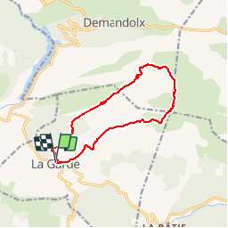
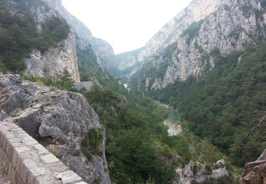
Trail Walking of 13 km to be discovered at Provence-Alpes-Côte d'Azur, Alpes-de-Haute-Provence, La Garde. This trail is proposed by GrouGary.
Description
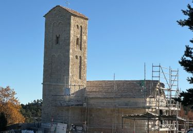
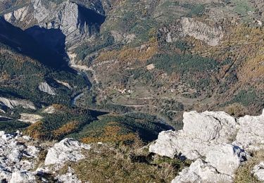
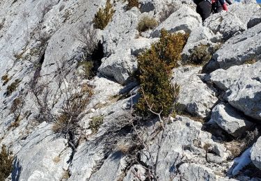
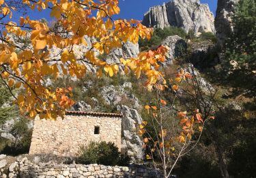
Montée facile mais soutenue par la Chapelle jusqu'au sommet du Teillon. Suivi des crêtes du Teillon sans difficultés. Mais la descente pour rejoindre le GR4 se fait dans une zone accidentée et raide. (Conseil : rejoindre le GR4 plus au Nord)
Positioning
Country:
France
Region :
Provence-Alpes-Côte d'Azur
Department/Province :
Alpes-de-Haute-Provence
Municipality :
La Garde
Location:
Unknown
Start:(Dec)
Start:(UTM)
303619 ; 4855960 (32T) N.
Comments
Trails nearby
![Trail Walking Castellane - castellane - Photo](https://media.geolcdn.com/t/375/260/ef06b05b-8807-4e7d-9459-ab4108fe9a75.jpg&format=jpg&maxdim=2)
![Walking Walking](https://static1.geolcdn.com/sitytour/trail-icons/101.png)
castellane
Walking
Medium
Castellane,
Provence-Alpes-Côte d'Azur,
Alpes-de-Haute-Provence,
France
![](/images/other/stat-length.png)
4.7 km | 8 km-effort
1h 26min
![](https://static1.geolcdn.com/siteimages/upload/files/16400158638029165_repeat_loop_refresh_sync_direction_icon.png)
Yes
![Trail Walking Castellane - Thyrs : sommet du Robion - Photo](https://media.geolcdn.com/t/375/260/3680539f-2862-441a-8ad7-00c7f20ab3d6.jpg&format=jpg&maxdim=2)
![Walking Walking](https://static1.geolcdn.com/sitytour/trail-icons/101.png)
Thyrs : sommet du Robion
Walking
Difficult
Castellane,
Provence-Alpes-Côte d'Azur,
Alpes-de-Haute-Provence,
France
![](/images/other/stat-length.png)
14.6 km | 28 km-effort
6h 16min
![](https://static1.geolcdn.com/siteimages/upload/files/16400158638029165_repeat_loop_refresh_sync_direction_icon.png)
Yes
![Trail Walking Castellane - robion castellane 1226m 15k - Photo](https://media.geolcdn.com/t/375/260/af2d1cc1-871e-4673-a0a2-9fb42183b9b6.jpg&format=jpg&maxdim=2)
![Walking Walking](https://static1.geolcdn.com/sitytour/trail-icons/101.png)
robion castellane 1226m 15k
Walking
Very difficult
Castellane,
Provence-Alpes-Côte d'Azur,
Alpes-de-Haute-Provence,
France
![](/images/other/stat-length.png)
13.9 km | 27 km-effort
7h 50min
![](https://static1.geolcdn.com/siteimages/upload/files/16400158638029165_repeat_loop_refresh_sync_direction_icon.png)
Yes
![Trail Walking Castellane - 2023-10-27 Sommet de Destourbes - Photo](https://media.geolcdn.com/t/375/260/8d68e8d2-0441-4ed4-bdff-8fb2a451cd76.jpg&format=jpg&maxdim=2)
![Walking Walking](https://static1.geolcdn.com/sitytour/trail-icons/101.png)
2023-10-27 Sommet de Destourbes
Walking
Difficult
Castellane,
Provence-Alpes-Côte d'Azur,
Alpes-de-Haute-Provence,
France
![](/images/other/stat-length.png)
13.6 km | 24 km-effort
5h 33min
![](https://static1.geolcdn.com/siteimages/upload/files/16400158638029165_repeat_loop_refresh_sync_direction_icon.png)
Yes
![Trail Walking Castellane - robion sommet - Photo](https://media.geolcdn.com/t/375/260/35aeebc6-8e72-4d90-b088-f9b1ec0701d6.jpg&format=jpg&maxdim=2)
![Walking Walking](https://static1.geolcdn.com/sitytour/trail-icons/101.png)
robion sommet
Walking
Very difficult
Castellane,
Provence-Alpes-Côte d'Azur,
Alpes-de-Haute-Provence,
France
![](/images/other/stat-length.png)
16.6 km | 32 km-effort
8h 17min
![](https://static1.geolcdn.com/siteimages/upload/files/16400158638029165_repeat_loop_refresh_sync_direction_icon.png)
Yes
![Walking Walking](https://static1.geolcdn.com/sitytour/trail-icons/101.png)
Castellane - Chapelle St Thyrs - Petit Robion - Sommet Robion - Gorges du Rayaup
Walking
Difficult
Castellane,
Provence-Alpes-Côte d'Azur,
Alpes-de-Haute-Provence,
France
![](/images/other/stat-length.png)
15.2 km | 28 km-effort
4h 26min
![](https://static1.geolcdn.com/siteimages/upload/files/16400158638029165_repeat_loop_refresh_sync_direction_icon.png)
Yes
![Trail Walking Castellane - Teillon - Photo](https://media.geolcdn.com/t/375/260/9fa8030d-94a4-48da-82af-f005a5d50e5c.jpg&format=jpg&maxdim=2)
![Walking Walking](https://static1.geolcdn.com/sitytour/trail-icons/101.png)
Teillon
Walking
Very difficult
Castellane,
Provence-Alpes-Côte d'Azur,
Alpes-de-Haute-Provence,
France
![](/images/other/stat-length.png)
19.3 km | 37 km-effort
6h 24min
![](https://static1.geolcdn.com/siteimages/upload/files/16400158638029165_repeat_loop_refresh_sync_direction_icon.png)
Yes
![Trail Walking Castellane - Teillon - Photo](https://media.geolcdn.com/t/375/260/75e05684-3e5a-45df-b020-9b5d507f504c.jpg&format=jpg&maxdim=2)
![Walking Walking](https://static1.geolcdn.com/sitytour/trail-icons/101.png)
Teillon
Walking
Easy
Castellane,
Provence-Alpes-Côte d'Azur,
Alpes-de-Haute-Provence,
France
![](/images/other/stat-length.png)
18.5 km | 35 km-effort
6h 29min
![](https://static1.geolcdn.com/siteimages/upload/files/16400158638029165_repeat_loop_refresh_sync_direction_icon.png)
Yes
![Trail Motorbike Castellane - GTA 2018 - ETAPE 7 - Photo](https://media.geolcdn.com/t/375/260/77602d7d-8b64-4a24-9542-1379774cf856.jpg&format=jpg&maxdim=2)
![Motorbike Motorbike](https://static1.geolcdn.com/sitytour/trail-icons/402.png)
GTA 2018 - ETAPE 7
Motorbike
Easy
Castellane,
Provence-Alpes-Côte d'Azur,
Alpes-de-Haute-Provence,
France
![](/images/other/stat-length.png)
203 km | 0 m-effort
10h 30min
![](https://static1.geolcdn.com/siteimages/upload/files/16400158638029165_repeat_loop_refresh_sync_direction_icon.png)
No